The Mines and Geosciences Bureau Regional Office No. XIII continued its Information, Education and Communication (IEC) Campaign of the 1:10,000 scale geohazard maps and the presentation of the highlights of the Results of the 1:10K Geohazard Mapping and Assessment in the Provinces of Agusan del Norte, Agusan del Sur and Surigao del Norte from July to August 2016. A total of two hundred fifteen (215) barangays, six (6) municipalities and two (2) cities were covered by the IEC Campaign on the following dates:
- Thirty-one (31) barangays of Cabadbaran City, ADN – July 14-15, 2016
- Twenty (20) barangays of Del Carmen, Siargao – August 1, 2016 Islands, SDN
- Twenty-nine (29) barangays of Dapa, Siargao – August 2, 2016 Islands, SDN
- Nineteen (19) barangays of General Luna, Siargao – August 3, 2016 Islands, SDN
- Fourteen (14) barangays of Socorro, SDN – August 4, 2016
- Forty-three (43) barangays of Bayugan City, ADN – August 11-12, 2016
- Twenty-seven (27) barangays of San Francisco, ADN – August 19, 2016
- Thirty-two (32) barangays of Prosperidad, ADS – August 20, 2016
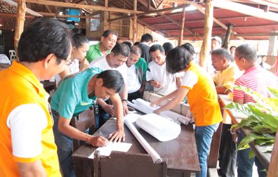
Municipal/City Mayors, Provincial/City Disaster Risk Reduction Management Officers, Key Officers, Members of the Municipal/City Disaster Risk Reduction Management Council and Barangay Captains or Representatives of the above-mentioned areas were among the participants during the IEC.
The main purpose of the IEC was to provide the Barangay LGUS with 1:10,000 scale geohazard maps and present the highlights of the Results of the 1:10K Geohazard Mapping and Assessment. Considering the increasing occurrence of natural disasters, the said IEC fostered and intensified collaborative efforts among the national and local governments and communities to ensure that utmost consciousness, preparedness and response to disasters are achieved.
 Mr. Romeo M. Dalodado, Geosciences Division Chief of MGB ROXIII informed the participants that MGB will not only distribute the 1:10,000 scale geohazard maps to LGUs but the Office will also conduct lectures and map reading exercises. He explained the importance of geohazard maps especially on the part of Bottoms Up Budgeting for LGUs considering that the Department of Budget and Management (DBM) required LGUs to secure a Geohazard Certification for any proposed government projects from MGB prior to the release of its funds/budget. He added that a geohazard map could be used as a tool for selecting areas to be developed as relocation/evacuation site and could be used in integrating disaster risk reduction and climate change adaptation initiatives in development/land use plan of barangays, municipalities and cities.
The highlights of the Results of the 1:10,000 scale Landslide and Flood Assessment of the municipalities/cities during the IEC Campaign were presented by the following geologists: Ms. Liza T. Pacete – Cabadbaran City, Agusan del Norte and Del Carmen, Siargao Islands, Surigao del Norte; Mr. Ralph Angelo E. Plaza – Cabadbaran City, Agusan del Norte and Dapa and General Luna, Siargao Islands, Surigao del Norte; Mr. Melvin A. Mantilla and Ms. Kate A. Boquilon – Socorro, Surigao del Norte; Ms. Elaine L. Galido – Bayugan City, Agusan del Norte and San Francisco, Agusan del Sur and Ms. Rubenar L. Cagubcob – Bayugan City, Agusan del Norte and Prosperidad, Agusan del Sur.
Recommendations suitable for areas assessed were discussed and provided by MGBRO XIII in the Landslide and Flood Threat Advisories of each barangays.
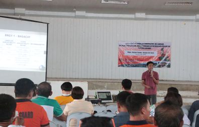
Engr. Esperidion Y. Amper, Jr, SRS I/ICT Focal Person, gave a lecture on how to read and interpret 1:10k scale geohazard maps for M/BLGUs preparedness and awareness of dealing with rain induced hazards in their respective areas. Prior to the distribution of 1:10K geohazard maps per quadrangle per barangay, the participants were required to take part in an actual workshop demonstration to gauge how well the participants have learned about map reading.
Ms. Cecilia L. Consuegra, Chair of the Regional Gender and Development Focal Point System, gave a brief discussion about Demographic Profiling. She requested the M/B DRRMO to help the GAD team gather the Demographic Profile of their respective barangays/ municipalities to be incorporated in the geohazard maps. She also stated that gender perspective will be integrated in the geohazard mapping and assessment.
On the same note, the MGB ROXIII GSD IEC team distributed Information, Education and Communication (IEC) materials regarding landslide, flood, storm surge and other geologic hazards. Apart from intensifying public awareness of natural hazards, the said materials will also aid in the effective and efficient management of disasters and reduction of casualties and damages to lives and properties.