MGB conducts Strategic Planning for Marine Geological Survey and Research

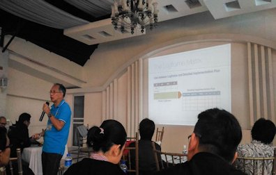
The Marine Geological Survey Division (MGSD) of the Mines and Geosciences Bureau Central Office conducted a Seminar-Workshop on Strategic Planning for Marine Geological Survey and Research on January 22-26, 2018 at the Bali Village Hotel Resort in Tagaytay City. The said activity was participated by representatives of all Regional Offices. Two geologists from MGB Regional Office No. XIII Geosciences Division took part in the seminar-workshop. The activity started with a program wherein Engr. Glenn Marcelo C. Noble, Chief of Planning, Policy and International Affairs Division of MGB Central Office, delivered his opening remarks followed by the discussion of Philippine Development Plan (PDP), General Appropriations Act (GAA), Program Expenditure Classification (PRExC) and National Expenditure Program (NEP). On the second day of the seminar-workshop, the discussion was about Project Life Cycle. Engr. Noble explained the stages of a project from Situation Analysis Stage all through the end stage which is the Project continue reading : MGB conducts Strategic Planning for Marine Geological Survey and Research

MGB RXIII conducts Geologic Quadrangle Mapping in Bicol Region

The Mines and Geosciences Bureau Regional Office No. XIII conducted the Geologic Quadrangle Mapping on May 2 to June 11, 2017 in Bicol Region. A team of three geologists and one GIS Operator from MGB RXIII conducted the Geologic Quadrangle Mapping in two quadrangles, namely Polangui and Ligao. The Polangui Quadrangle comprises five municipalities and one city ‒ Balatan and Bato, Camarines Sur and Libon, Polangui, Oas, and Ligao City, Albay. On the other hand, the Ligao Quadrangle has 7 municipalities and 3 cities ‒ Polangui, Oas, Guinobatan, Camalig, Daraga, Santo Domingo, Malilipot, Ligao City, Legazpi City and Tabaco City. The updating of Polangui Quadrangle which has an unpublished geologic map was done on the first phase of the fieldwork (May 2-May 19). The team subsequently proceeded to work on Ligao Quadrangle on the second phase of the fieldwork (May 22-June 11). Methodologies used were river/creek traversing, examining outcrops, exposures, continue reading : MGB RXIII conducts Geologic Quadrangle Mapping in Bicol Region

MGB RXIII carries on with its Coastal Geohazard Assessment

The Mines and Geosciences Bureau Regional Office No. 13 carried on with its Coastal Geohazard Assessment under the National Geohazard Assessment and Mapping Program. For the first quarter of 2017, the target municipalities of MGB RXIII are Barobo, Lianga, Hinatuan and Bislig in the Province of Surigao del Sur. As for the second quarter, the Municipality of Del Carmen in the Province of Surigao del Norte was assessed on May 31 to June 7, 2017. The Municipality of Socorro in the Province of Surigao del Norte will be assessed by the third week of June 2017. The Philippines has one of the longest coastlines in the world with an estimated extent of 36,289 kilometers. Approximately 46% of the total population in the Philippines resides in coastal areas, directly or indirectly relying on coastal resources as source of livelihood, habitation, and recreation. Many of the coastal areas are inherently vulnerable to continue reading : MGB RXIII carries on with its Coastal Geohazard Assessment

MGB RXIII conducts Vulnerability and Risk Assessment

The Mines and Geosciences Bureau Regional Office No. 13 is currently conducting the Vulnerability and Risk Assessment (VRA) under the National Geohazard Assessment and Mapping Programme. For the first quarter of 2017, the target municipalities of MGB RXIII are Magallanes and Las Nieves in the Province of Agusan del Norte. As for the second quarter, the Municipalities of Sibagat and Sta. Josefa in the Province of Agusan del Sur were assessed last April until the second week of May. For the rest of May until June, MGB RXIII will conduct VRA in the Municipalities of San Miguel and Tago in the Province of Surigao del Sur. The Vulnerability and Risk Assessment is an activity following the 1:10,000 Scale Geohazard Mapping and Assessment which was concluded in 2015. The primary objective of VRA is to evaluate the existing vulnerability conditions within a municipality/city from rain-induced landslide and flood that could potentially continue reading : MGB RXIII conducts Vulnerability and Risk Assessment

MGB RXIII conducts Groundwater Resource and Vulnerability Assessment

The Mines and Geosciences Bureau Regional Office No. XIII conducted Groundwater Resource and Vulnerability Assessment from January to April 2017 in four (4) municipalities of Agusan del Norte and Province of Dinagat Islands. A team of geologists, geologic aide, and laboratory technician from the MGB RXIII Geosciences Division conducted the said assessment in the following municipalities covering forty-seven (47) barangays: Municipality                                     No. of Barangays Las Nieves, Agusan del Norte                             20 Magallanes, Agusan del Norte                              8 Loreto, Province of Dinagat Islands               10 Tubajon, Province of Dinagat Islands              9 One of the functions of the Mines and Geosciences Bureau is the conduct of specialized researches and assessment of the country’s groundwater resources. The Groundwater Resource and Vulnerability Assessment Program is a major activity that the continue reading : MGB RXIII conducts Groundwater Resource and Vulnerability Assessment

MGB RXIII joins the conduct of CY 2017 1st Quarter National Simultaneous Earthquake Drill

The Mines and Geosciences Bureau Regional Office No. XIII joined the conduct of the CY 2017 1st Quarter National Simultaneous Earthquake Drill (NSED) on March 31, 2017 at 2:00 P.M. The primary purpose of the earthquake drill is to test the response capacity and capability of MGB RXIII employees to earthquake incidents. Mr. Romeo M. Dalodado, MGB RXIII Geosciences Division Chief, gave a brief presentation on “How to Conduct an Earthquake Drill” that serves as a guide for employees to what should be done before, during and after an earthquake.  He also discussed the different stages in conducting the earthquake drill which include Planning/Organizing an Earthquake Drill, Developing the Earthquake Evacuation Plan, Orientation Prior to the Conduct of an Earthquake Drill and Actual Conduct of an Earthquake Drill.  Since the earthquake drill is performed quarterly every year, Mr. Dalodado reminded the employees of the established evacuation route and muster point/assembly continue reading : MGB RXIII joins the conduct of CY 2017 1st Quarter National Simultaneous Earthquake Drill

MGB RXIII Geologists attend 2017 National Quadrangle Geological Mapping Workshop

A team of geologists from the Mines and Geosciences Bureau Regional Office No. XIII attended the 2017 National Quadrangle Geological Mapping Workshop on February 5-11, 2017 at Ninong’s Hotel in East Washington, Legazpi City. The said workshop was hosted by the Mines and Geosciences Bureau Regional Office No. V. Mr. Romeo M. Dalodado, Chief Geologist; Melvin A. Mantilla, Supervising Geologist; Janeth S. Aparri, Geologist II; and Ralph Angelo B. Plaza, Geologist II of the MGB RXIII Geosciences Division participated in the workshop. The first day was set for the deliberation, review and editing of the Geologic Quadrangle Maps of Region III. On the second day, lecturers discussed the geology of CALABARZON and Bicol Region. The lectures and workshop on quadrangle map generation and basic skills in geologic mapping were discussed on the third day and participants were given some exercises on aerial photo interpretation using the fieldwork site photos later continue reading : MGB RXIII Geologists attend 2017 National Quadrangle Geological Mapping Workshop

MGB ROXIII carries on with its Groundwater Resources Assessment Program

The Mines and Geosciences Bureau Regional Office No. XIII conducted the Groundwater Resources Assessment on September 13 to October 8, 2016 in the Municipalities of San Miguel, Bayabas, Cantilan and Carrascal in Surigao del Sur. A team of geologists and geologic mappers from the Geosciences Division of MGB ROXIII was divided into two groups to conduct Groundwater Resources Assessment in all 56 barangays of the four aforementioned municipalities. Aside from well inventory, the team surveyed every water source in each barangay. Water source can be a well or a spring. General information like geology and geomorphology of the area was noted.  Similarly, the well construction data such as well usage, well type, drilling method and pump type as well as the spring and the rock type data were taken during the survey. The team took water samples of each major water source in all barangays for pH and alkalinity test. continue reading : MGB ROXIII carries on with its Groundwater Resources Assessment Program

MGB ROXIII conducts Vulnerability and Risk Assessment in Esperanza and Veruela, Agusan del Sur

The Mines and Geosciences Bureau Regional Office No. XIII conducted the Vulnerability and Risk Assessment (VRA) on September 19 to October 14, 2016 in the Municipalities of Esperanza and Veruela in the Province of Agusan del Sur. A team of geologists and geologic mappers from the Geosciences Division of MGB ROXIII was divided into three groups to conduct the Vulnerability and Risk Assessment (VRA) in all barangays of the two aforementioned municipalities. On September 19, 2016, the team paid a courtesy call on the Local Government Unit (LGU) – Municipal Disaster Risk Reduction Management Office (MDRRMO) and the Office of the Mayor of Esperanza to inform them that the MGB ROXIII team will conduct the Vulnerability and Risk Assessment. The Barangay LGU and the MGB ROXIII team also discussed the survey schedule. Minor problems encountered during the survey were the transportation and accessibility of roads in distant sitios. After the continue reading : MGB ROXIII conducts Vulnerability and Risk Assessment in Esperanza and Veruela, Agusan del Sur

MGB ROXIII continues IEC Campaign of 1:10,000 scale geohazard maps

The Mines and Geosciences Bureau Regional Office No. XIII continued its Information, Education and Communication (IEC) Campaign of the 1:10,000 scale geohazard maps and the presentation of the highlights of the Results of the 1:10K Geohazard Mapping and Assessment in the Provinces of Agusan del Norte, Agusan del Sur and Surigao del Norte from July to August 2016. A total of two hundred fifteen (215) barangays, six (6) municipalities and two (2) cities were covered by the IEC Campaign on the following dates: Thirty-one (31) barangays of Cabadbaran City, ADN – July 14-15, 2016 Twenty (20) barangays of Del Carmen, Siargao – August 1, 2016 Islands, SDN Twenty-nine (29) barangays of Dapa, Siargao – August 2, 2016 Islands, SDN Nineteen (19) barangays of General Luna, Siargao – August 3, 2016 Islands, SDN Fourteen (14) barangays of Socorro, SDN – August 4, 2016 Forty-three (43) barangays of Bayugan City, ADN – continue reading : MGB ROXIII continues IEC Campaign of 1:10,000 scale geohazard maps