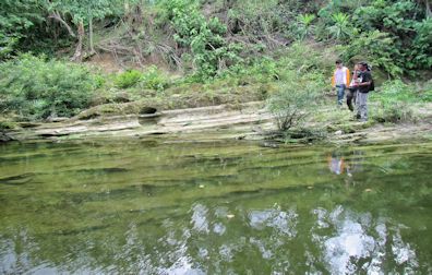
The Mines and Geosciences Bureau Regional Office No. XIII conducted the Geologic Quadrangle Mapping on May 2 to June 11, 2017 in Bicol Region. A team of three geologists and one GIS Operator from MGB RXIII conducted the Geologic Quadrangle Mapping in two quadrangles, namely Polangui and Ligao. The Polangui Quadrangle comprises five municipalities and one city ‒ Balatan and Bato, Camarines Sur and Libon, Polangui, Oas, and Ligao City, Albay. On the other hand, the Ligao Quadrangle has 7 municipalities and 3 cities ‒ Polangui, Oas, Guinobatan, Camalig, Daraga, Santo Domingo, Malilipot, Ligao City, Legazpi City and Tabaco City. The updating of Polangui Quadrangle which has an unpublished geologic map was done on the first phase of the fieldwork (May 2-May 19). The team subsequently proceeded to work on Ligao Quadrangle on the second phase of the fieldwork (May 22-June 11). Methodologies used were river/creek traversing, examining outcrops, exposures, continue reading : MGB RXIII conducts Geologic Quadrangle Mapping in Bicol Region